Hema 4WD Maps Australia
- 0.0
- Rating
- 10.00K
- Installs
- $69.99
- Price

 Analysis by App-foxy
Choosing an off-road navigation app is different from choosing a city map. On sealed roads, a missed turn usually costs a few minutes. In remote country, the useful question is whether the map remains practical when mobile coverage disappears, whether the phone can handle a long day of navigation, and whether the information is suited to tracks rather than suburban streets. That is the space where Hema 4WD Maps Australia aims to be useful.
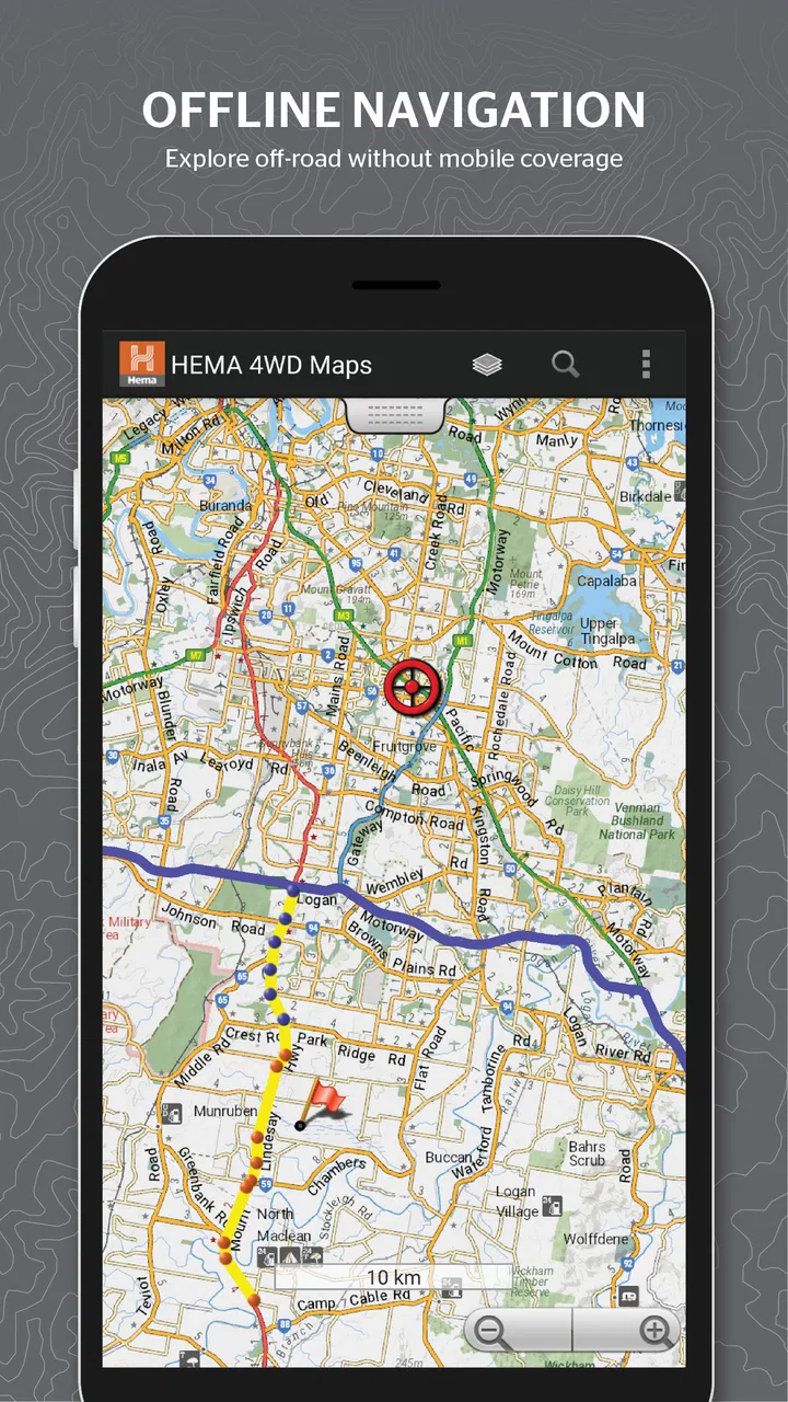
I see it as a specialist Maps & Navigation app from Hema Maps Pty Ltd, built for people who plan four-wheel-drive trips in Australia rather than ordinary daily commuting. Its central appeal is straightforward: it is intended to provide offline mapping for off-road travel. The app is available for Everyone, has passed the ten-thousand-install mark, and costs $69.99, so it is clearly aimed at users who expect navigation to be an important part of a trip, not a casual extra.
After spending time with it, my opinion is that the price makes sense only when you regularly travel beyond dependable reception or want a more focused tool for Australian 4WD planning. It is not the obvious choice for someone who only needs directions to work, nor would I treat it as a universal replacement for every navigation app on a phone. Its value comes from the kind of journey it supports and from preparing before leaving, not from adding another map to an everyday app folder.
You May Also Like

 Pandora - Music & Podcasts
Pandora’s Music Is Easy to Start, but Harder to Recover
Pandora’s strength is its low-effort path from a seed to a station. Its weak spot is how much confidence it asks you to place in connection, setup, and quiet recovery.

 AccuWeather: Weather Radar
AccuWeather Review: A Quick, Clear Forecast for Everyday Decisions
For everyday plans, the best forecast is the one you can understand quickly. AccuWeather makes rain timing, radar, and local conditions easy to act on, with a few trade-offs.

 Hill Climb Racing
Why Hill Climb Racing Still Turns Crashes Into One More Run
A tiny car, a bumpy hill and one more upgrade: Hill Climb Racing keeps resurfacing because its simple chaos makes every near-miss feel personal.

 AliExpress - Shopping App
AliExpress Makes Global Shopping Feel Personal, but Shoppers Bear the Risk
AliExpress turns a global marketplace into a pocket-sized discovery engine. Its reach is useful, its shopping loop compelling, and its trade-offs easy to miss.

 Lords Mobile: Kingdom Wars
Lords Mobile Is a Kingdom-Building Routine, Not a Quick Match
A case-by-case verdict on the building, battles, device demands, and social commitments that make Lords Mobile rewarding for some players and exhausting for others.

 PDF Scanner app - TapScanner
TapScanner Makes Paperwork Easier to Capture, Check, and Share
TapScanner makes scanning with a phone feel less like a rescue operation and more like a dependable step in getting work done. Its capture tools are useful, though not flawless.
More From Our News Desk
View All News


How it feels when you plan and navigate a trip
I approach a dedicated 4WD map differently from a general navigation app: I want to know how I’ll prepare a route before leaving coverage and how I’ll use the screen without distracting the driver. That planning routine matters as much as the map itself. It also leads to a more practical look at what the app can—and cannot—settle once the trip is underway.
Speed expectations before leaving home
The first thing I would change in my own routine is to treat this as a preparation tool as much as a driving tool. Offline navigation is most useful when the route, map coverage, and device are ready before the vehicle leaves reliable internet access. Opening an app at a remote campsite and expecting it to solve every planning problem is a poor workflow, regardless of how good the underlying map may be.
In normal use, the experience should feel most comfortable when I already know the broad area I am exploring. I would search, inspect the route, and make sure the relevant map material is available while connected. That approach also reduces pressure on the phone during the trip. Instead of repeatedly waiting for online content, the device can concentrate on displaying the map and helping me maintain awareness of the track.
There is an important distinction between perceived speed and actual usefulness here. A simple road app can feel faster because it is designed around familiar streets, automatic rerouting, and short journeys. A 4WD map has a different job: showing context around a route, helping me judge alternatives, and supporting decisions before a turn becomes urgent. I would rather have a slightly more deliberate planning process than discover that my chosen route was not prepared for offline use after leaving coverage.
The $69.99 purchase also changes how I judge responsiveness. I would not recommend buying it solely to test whether it feels quicker than a free road-navigation app. The reason to consider it is the specialist focus on Australian off-road travel. If that focus matches your trips, the initial setup time is part of the value. If it does not, the price will feel difficult to justify even if the app opens promptly.
What happens during heavy-use moments
The demanding moments are not necessarily a single fast interaction. They are long stretches of use: the screen staying on while the vehicle moves, frequent glances at the route, zooming between a detailed track and the surrounding area, and checking progress after a change of direction. A phone that performs well for a ten-minute drive can still become inconvenient during a full day outside, so I would test the complete setup before relying on it for an important trip.
My practical advice is to use a proper vehicle mount, keep the display readable without constant touching, and carry a charging solution suitable for the vehicle. That is not a criticism aimed only at Hema 4WD Maps Australia; it is the reality of using any navigation app for extended periods. The map may be offline, but the phone still depends on its battery, storage, screen, and location hardware.
Heavy use also exposes a planning trade-off. A broad view is valuable for understanding where a track leads, while a close view is better for making a turn with confidence. Switching between those views repeatedly can become tiring if the phone is mounted too low or if the display is difficult to read in sunlight. I would set the mount and screen position before departure, then avoid making the driver perform detailed map work while moving. A passenger should handle route inspection whenever possible.
Another useful habit is to keep a second form of orientation. That could be a planned itinerary shared with someone at home, a paper reference, or simply a written note containing the next major destination. I would not interpret offline mapping as permission to ignore trip planning. It reduces dependence on a network connection; it does not remove the need to understand the route or make sensible decisions when conditions change.
Stability and recovery when the trip changes
For me, reliability in an off-road app means more than avoiding a crash. It means being able to recover calmly after taking a wrong turn, stopping for a break, changing the destination, or temporarily losing a clear view of the route. The best way to improve that experience is to prepare several likely sections of the journey rather than only the first destination. Remote travel rarely follows the neat sequence planned at the kitchen table.
I would also avoid making major route decisions while the vehicle is moving. Stop safely, let the driver concentrate on the surroundings, and then inspect the map. This is especially important on tracks where a turn may be easy to miss and where reversing or turning around is less convenient than it would be on a normal road. The app can support the decision, but it cannot judge the physical condition of a track or replace local caution.
Recovery is strongest when I use the map as a reference instead of assuming that every line on a screen represents a guaranteed passage. Weather, closures, private access, vehicle clearance, and seasonal conditions can all change the practical meaning of a route. I would use the app to understand position and options, then confirm the real-world situation through current local information where appropriate.
This is one of the less obvious trade-offs of specialist mapping. More relevant off-road context can encourage adventurous planning, but it can also make a route look more certain than it feels from the driver’s seat. My rule would be simple: if the track, conditions, fuel range, or vehicle capability raises doubt, pause and reassess rather than treating the map as an instruction to continue.
Device limits that matter more than the app itself
The phone is part of the navigation system, so its limits deserve attention. Storage matters because offline material occupies space, and I would leave room for the operating system and other essential apps rather than filling the device completely before a trip. A phone that is nearly full can become harder to manage at exactly the wrong time, even if the map itself is well prepared.
Heat is another concern. A handset mounted behind a windscreen can become hot, especially with the display active and the device charging. I would keep it shaded where possible, remove an unnecessarily thick case during demanding use, and watch for signs that the phone is reducing performance. If the device becomes too hot, the sensible response is to stop safely and cool it rather than continue staring at a dim or unstable screen.
Older phones may also make the experience less comfortable. A larger, brighter display is easier to read at a glance, while a small screen demands more zooming and touching. I would not buy a new handset solely for this app, but I would honestly assess whether my current phone can show a detailed route without forcing me to take attention away from the road. A tablet can offer a better planning view, yet it may be less convenient to mount securely in a vehicle.
Battery planning should be treated as essential. Offline maps reduce reliance on mobile data, but they do not make the phone independent of power. I would begin with a full charge, use a reliable vehicle charger, and carry a backup power option when the trip is remote. I would also keep the phone’s normal communication functions available rather than assuming the navigation app is the only thing that matters.
These constraints affect perceived speed as well. A phone that is hot, low on storage, or nearly out of battery can feel slow even when the app is behaving normally. When someone tells me an app is sluggish, I want to know whether the same problem appears on a cool, charged device with adequate free space. That is the sort of basic test I would perform before blaming the map application.
Who gets the most from this app
The strongest audience is an Australian 4WD owner who regularly plans trips away from dependable reception and wants a dedicated off-road mapping experience. It also suits people who prefer to study routes before departure, compare possible paths, and keep navigation available when online services are unreliable. For those users, the one-time price can be easier to accept because the app supports a specific travel habit rather than a single weekend experiment.
I can also see value for a passenger acting as navigator. In that role, the app becomes a shared planning screen: the driver focuses on the track, while the passenger watches progress, checks the next decision, and helps the group understand where they are. This reduces hurried interactions and makes the map more useful as a conversation tool, not just a turn prompt.
It is less suitable for a person who spends nearly all their time in cities, wants live traffic, or expects the same automatic convenience as a mainstream road-navigation service. Someone who takes an occasional rental-car holiday may be better served by an app they already know, especially if the trip stays on sealed roads. I would also hesitate to recommend it to anyone who dislikes preparation. The offline advantage is most valuable when the user plans ahead.
How it compares with everyday alternatives
Compared with a familiar online road map, Hema 4WD Maps Australia has a narrower purpose. Everyday alternatives are usually better for addresses, commuting, business searches, live road conditions, and quick changes during an urban drive. They are also easier to recommend to a mixed group of users because most people already understand their basic workflow.
Where this app can make more sense is the transition from ordinary roads to remote tracks. A general map may help me reach the start of an adventure, but it is not necessarily the tool I would choose for understanding an off-road itinerary. The specialist focus gives Hema Maps Pty Ltd a clearer reason to exist than simply offering another city map with a different color scheme.
There is still room for both. I would use a conventional navigation app for the drive through towns and a dedicated 4WD map for the remote section, provided I had prepared the relevant offline material. That combination is more realistic than demanding one app handle every part of a long Australian journey equally well.
A realistic day on the track
Imagine leaving a regional town after checking the route at breakfast. I would use the phone while connected to prepare the area ahead, mount it where both driver and passenger can see it, and begin with the broad route rather than an over-zoomed view. Once the signal becomes unreliable, the important benefit is that the trip does not depend on continuously downloading map content.
At a fork, I would slow down, let the passenger examine the map, and compare the planned direction with what is physically visible. If the group decides to stop early, I would reassess from a safe location instead of trying to improvise while driving. Later, if the route changes because of weather or a closed section, the app can help me understand the surrounding options, but I would still apply common sense and confirm whether continuing is sensible.
At the end of the day, I would recharge the phone, review the next section, and make sure the following area is ready before leaving camp. That small routine is one of the most practical ways to improve reliability. It turns the app from a last-minute rescue tool into part of a repeatable navigation process.
My performance verdict
I judge Hema 4WD Maps Australia as a focused tool whose performance depends heavily on preparation and hardware. Its offline purpose is the main reason to consider it, while long screen-on sessions, heat, battery life, storage, and visibility determine how pleasant it feels in practice. I would not promise effortless navigation on every phone or every track, but I would trust the concept more for planned Australian 4WD travel than for ordinary road use.
The app was released on March 17, 2020, and its Everyone age classification makes it broadly accessible from a content standpoint. The more important question is whether the user’s travel style matches the product. The install base of over ten thousand suggests a specialist audience rather than a mass-market navigation crowd, which fits my impression: this is a purposeful purchase for a particular kind of driver.
My recommendation is conditional but positive: choose it if offline Australian off-road mapping is central to your trips, you are willing to prepare routes in advance, and your phone can handle extended navigation in a vehicle. Skip it if you mainly need live urban directions, traffic information, or a free app for occasional sealed-road travel. At $69.99, it should earn its place through regular use and better confidence away from coverage, not through novelty.
In the end, I would see Hema 4WD Maps Australia as one component of a responsible off-road setup. It can make route planning more focused and reduce dependence on mobile reception, but it cannot replace vehicle preparation, local awareness, battery planning, or a sensible decision to turn back. Used with those habits, it is a credible companion for Australian 4WD adventures; used as a magic answer to every remote-navigation problem, it is the wrong tool.
FAQs for Hema 4WD Maps Australia
01What is Hema 4WD Maps Australia used for?
Hema 4WD Maps Australia is designed for planning and navigating four-wheel-drive trips across Australia. It provides access to detailed off-road maps, tracks, campsites, points of interest, and travel information. The app is particularly useful for touring remote areas, finding suitable routes, and preparing trips where ordinary road-navigation apps may not include unsealed tracks or outback destinations.
02Does Hema 4WD Maps Australia work without mobile reception?
Yes, offline use is one of the most important features for travelling in remote Australia. Users can download selected map areas before leaving coverage, allowing them to view maps and navigate when there is little or no mobile signal. However, offline availability depends on downloading the required content in advance, so it is worth checking storage space, map coverage, and device battery before starting a trip.
03Does the app provide reliable information about 4WD tracks and campsites?
The app includes information intended to help drivers discover four-wheel-drive tracks, camping areas, attractions, and remote touring routes. Nevertheless, conditions in Australia can change quickly because of weather, fires, closures, roadworks, seasonal access restrictions, and local regulations. Treat the app as a planning and navigation aid rather than the only source of safety information, and confirm conditions with authorities when possible.
04Can beginners use Hema 4WD Maps Australia, or is it only for experienced off-road drivers?
Beginners can use the app, especially for researching routes and understanding the types of tracks available before travelling. Its specialist mapping is also valuable to experienced drivers who need more detailed information than standard navigation apps provide. However, the application cannot replace four-wheel-drive training, recovery equipment, weather awareness, or sensible trip preparation. New drivers should choose routes appropriate to their skills and vehicle.
05What should I check before downloading and using the app?
Before downloading Hema 4WD Maps Australia, check that your Android or iOS device meets the current requirements and has enough storage for offline maps. Review the app’s pricing model, subscriptions, and available map packages, since some features or content may require payment. Also verify that your preferred regions are covered, enable location services, and download maps before travelling outside reliable mobile coverage.
Pros
- Detailed 4WD tracks
- campsites
- and off-road points across Australia.
- Offline map support helps when travelling beyond mobile coverage.
- Trip-planning tools make it easier to prepare remote adventures.
- User updates can provide useful information on track conditions.
- Includes practical details such as difficulty
- access
- and vehicle requirements.
Cons
- Coverage and detail may vary considerably between different regions.
- Some advanced mapping features may require a paid subscription.
- Track information can become outdated after weather or road changes.
- Remote routes may lack enough safety information for inexperienced drivers.
- Large offline map downloads can use significant storage space.

Hema 4WD Maps Australia
Gallery